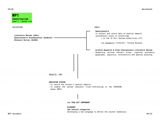
PULSE work plan is developed through the implementation of 6 Work Packages which are the backbone of the research outcomes.
WP01 – INVESTIGATION
Aims: Studying the evolution of the 16 Italian port systems (formalised in 2016 as a result of the Port Authority Reform, Legislative Decree No. 169) and acquiring an updated glossary for the cluster dimension, through the Literature Review (LRev), the Questionnaire Dissemination (QueDiss) and the Glossary Survey (GLOSS).
Activities: To analyse the spatial-institutional evolution that led to the formation of the cluster, phase 01 will carry out archive research, literature review (LRev) deepening various subject areas: regional economics, geography, logistics, architecture and spatial planning. The QueDiss will be possible thanks to the operational support of Assoporti - Association of Italian Ports (contact person: Dott. Tiziana Murgia, Head of Communication and Environment) and will submit the completion of the PULSE Questionnaire to the 16 port system authorities (AdSP). This activity forms an Indicator System by recording the cluster’s spatial impacts (e.g. degree of sea-land connectivity, infrastructure sharing/rationalization, services pooling/optimization, amount/size of functional and operational linkages, linear/areal occupation of the coast, proximity/inclusiveness of firms/industries, co-ordinated planning and project tools between ports in the same cluster, port-to-city or land-to-sea hinge and grafts, port-city-territory-interfaces extension and heterogeneity, dual-function architectures etc.). Within GLOSS, I will organise interviews for describing the Port-Cluster Landscape with new words.
Result: The Glossary – new lexical categories describing the port cluster spatial configurations and enabling the system indicator cross-referencing in the CROSSING phase (WP02).
Literature Review (LRev)
The LRev is based on the structuring of a multidisciplinary bibliography on the broader concept of cluster and on the application of the specific concept of cluster in relation to port systems and territories. The main goal of the LRev is to identify possible approaches, theories, scientific positions and/or experiments regarding the spatial component of port clusters.
The intention is, thus, to stress whether and how scholars from neighboring disciplines, ranging from economics, geography, logistics and planning, are dealing with the form-related and design aspects of the extended cluster dimension. The construction of the PULSE bibliography takes place through the search for reliable sources as recent as possible (last 20/25 years).
The disciplines investigated through these sources are maritime economics and geography, logistics, spatial planning and architecture. For each item a critical reading is set with the intention of building a corpus of texts on the concept of cluster. The choice not to differentiate the disciplines explored in this phase is functional to verify in which subject(s) the spatial component of the port cluster is treated, and in what way.
As an early result of the LRev, we can state that while sciences such as economics and maritime geography largely reflect on concepts such as “port region” or “port range”, the disciplines of space are absent on these issues, making the cluster a conceptual construct rarely transformed into a horizontal phenomenon with a relational and spatial dimension.
A critical selection of texts can be found in the Sources section.
--
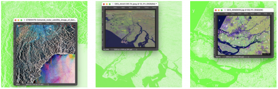
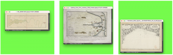
Iconographic Research
PULSE Iconographic Research is an ongoing side-project which investigates new representative tools to describe, recognise and design the landscapes produced by the port clustering phenomenon.
Large post-produced and re-elaborated maps using codes and colours to decipher the land-sea territories linked to the presence of large river or seaports, framing spaces without marking boundaries but emphasising the potential relations and latent overlaps enclosed in the notion of cluster.
Early maps, portolans and narrative engravings of the territories of world ports show their morphological and technical peculiarities, along with the physical components that build these network zones. What adds fundamental elements to these images is the spatial history of coastal places.
captions
img 01 The Rhine–Meuse–Scheldt Delta, 2007, ESA + NRL, Wikimedia Commons CC;
img 02 The Rhine–Meuse–Scheldt Delta, 2008, NASA World Wind, Wikimedia Commons CC;
img 03 Coloured radar satellite image of Genoa, n.d., ESA, EURIMAGE / SCIENCE PHOTO LIBRARY;
img 04 Portolan chart of Liguria, 1855, Éditeur : Lit. Armanino (GE), Wikimedia Commons CC;
img 05 Settlement at Port Jackson, Sydney Harbour, 1789, Francis Fowkes [attrib.], London: R. Cribb, Wikimedia Commons CC;
img 06 Carte de la Basse-Seine, entre Rouen et Le Havre, 1750 ca, Wikimedia Commons CC.
WP02 – CROSSING
02 – CROSSING
Aims: Cross-referencing the indicator system of the Italian case with those detected in the EU port clusters seen as reference cases and developing innovative maps to visualize the port cluster spatial dimension, through the Interviews Tour (InTour) and the Cross-referenced Maps (CROSSMaps).
Activities: The InTour will allow cross-comparison between the data obtained in phase 01 and the advanced clustering condition of selected, highly significant European cases, e.g. HAROPA Ports (FR), Port of Antwerp-Bruges (BEL), Port of Valencia, Sagunto, Gandìa (SP), APBA - Port of Algeciras Bay & Tarifa (SP), reached thanks to the operational support of AIVP - The Worldwide Network of Port Cities (contact person: Dott. Ing. Josè M Pagès Sànchez, Director of Agenda AIVP 2030, Projects and Content).The CROSSMaps will elaborate maps of three Italian port contexts, selected because they are emblematic following the activities of QueDiss and InTour, with the aim of visualising the spatial impacts defined in the Indicator System in concrete contexts and evaluating their application from a strategic perspective. The three Italian port contexts will be Port Network Authority of the Eastern Adriatic Sea (Ports of Trieste and Monfalcone), Port Network Authority of the North Tyrrhenian Sea (Ports of Livorno, Piombino, Capraia, Portoferraio and Rio Marina) and the Port System Authority of the Western Sicilian Sea (Ports of Palermo, Termini Imerese, Trapani, Porto Empedocle, Licata and Gela). Displaying of the impacts will be assumed to be as credible as possible.
Result: The Atlas of Maps – multi-level maps that will refer to the Port-City Level (1: 50,000) and the Architecture-Infrastructure Level (1:500). Used as spatial analysis tools, the maps will describe the Port-Cluster Landscape configurations and evolutions, while enabling the development of designing strategies in the FORMULATION phase (WP03).
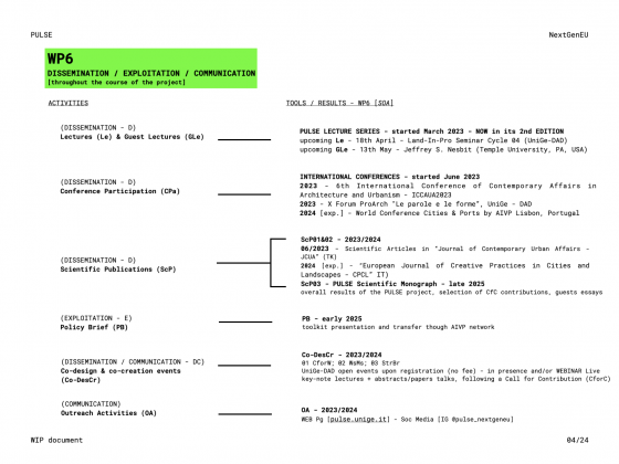
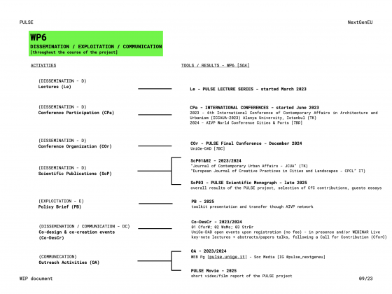
WP06 – DISSEMINATION, EXPLOITATION, COMMUNICATION
To maximise PULSE’s impacts, I will follow a Plan for Dissemination, Exploitation and Communication (PDEC) (see diagram below).
For scientific impacts, I will disseminate (D) the research results through scientific conferences (organisation and participation), scientific publications and lectures I will give within UniGe network, as well as in national and international universities.
For technological-economic impacts, I will use an Exploitation activity (E) to enable the wide circulation and reuse of the toolkit using the channels of UniGe, AIVP and PortCity Futures - PCF research group.
For societal impacts, I will employ Communication activities (C) using PULSE UniGe federated webpage and social media (mainly Instagram) and strong locally embedded communication platforms to boost public engagement. A Dissemination-Communication activity (DC) is also planned to offer unique co-design and co-creation experiences, leveraging the network of national and international knowledge and contacts established over the years and fostering an interdisciplinary approach between architecture, urban and spatial design, economics, human geography and anthropology.
Lectures (Le)
PULSE LECTURE SERIES
Lectures given by Principal Investigator as part of PULSE in Italian and foreign universities or public institutions.
Le01 "Port City, City Port, The Port and the City, The City and its Port. But even before, what is a Port?" held in the course Coastal Design and Other Extreme Environments (UniGe - DAD, IT, 20 February 2023).
Le02 "Beyond the Port City. Towards new Narratives and Strategies for Port-City Environments" held in the course Coastal Design and Other Extreme Environments (UniGe - DAD, IT, 27 February 2023).
Le03 "Land-Sea & Port-City Researches. Backgrounds, Foundations, new Routes" held in the course Adaptive Strategies. Designing Scenarios for Port Cities (TU Delft - NL, 22 March 2023).
Le04 "Extended Territories between Land and Sea. A set of Researches and Projects", held in the course Critical Grounds Lab: Insular Narratives 2023 (POLIMI - DASTU, 28 April 2023).
Le05 "PULSE. A collaborative projects about port clusters and port-related spaces" held in the framework of the Workshop "Italian Port Days - I porti italiani e il rapporto con le comunità" organized by Assoporti - Associazione porti italiani unitamente alle Autorità di sistema portuale italiane within the Festival dello Sviluppo Sostenibile 2023 (Roma, MIT, 18 May 2023).
Le06 "Land-Sea Spaces: from Research to Design", held in the Level II Master's degree Port City School. Per il governo delle città porto (University of Bari "Aldo Moro", 14 October 2023).
Le07 "The Port as a Landscape. Research & Design Experiences", to be held in the course Principles of Conservation within the Land-In-Pro 1st Seminar Cycle “Perspectives on (post)industrial heritage and landscapes” (UniGe, DAD, 18 April 2024).
--
PULSE GUEST LECTURE SERIES
Lectures by guests invited within the framework of PULSE and coming from renowned Italian and foreign universities or public institutions.
GLe01 "Ground Beyond Land. Aestethics, Programs and Politics of the Ocean as a Human Settlement" held by PhD Architect Matteo Vianello (UniGe - DAD, IT, 13 March 2023).
GLe02 "Inclusive Urbanism" held by Arch. Julian Schubert (Something Fantastic, GER) (UniGe - DAD, IT, 3 April 2023).
GLe03 "Learning by Portolans. Reading and Re-writing the built coastline" held by DD PhD Arch. Stefanos Antoniadis (Faculty of Architecture - FA, University of Lisbon - ULisboa) (UniGe - DAD, IT, 15 May 2023).
GLe04 "Water Challenges through the lens of Port Cities" held by PhD Arch. Paolo De Martino (Delft University of Technology / University of Venice, IUAV) (UniGe - DAD, IT, 22 May 2023).
All updates can be found in the PULSE Diary.